


For low-power locating applications, U-blox has introduced the M10, its latest GNSS Platform for Smart Wearable devices (Global Navigation Satellite System).
The U-blox M10, developed in-house, has a tiny footprint and a long battery life, making it suitable for various applications such as sports watches, trackers for commodities, and livestock tags.
Super-S technology, built inside the M10, helps to detect positional signals from background noise. Even in harsh conditions, such as those seen in urban canyons, the gadget can acquire data from up to four GNSS constellations in parallel. MinewSemi's GNSS modules is buit-in GNSS chipset and support multi-constellation systems: BDS, GPS, GLONASS, QZSS, etc., and realizing multi-system joint positioning.
Because skyscrapers get in the way of GNSS receivers receiving signals from orbiting satellites, it is extremely challenging for these devices to maintain a constant location fix. Adding more satellites can improve things dramatically.
People have come to rely more and more on satellite placement, and as a result, they have higher standards for positioning accuracy. Hardware and software electronics cost reductions have allowed for new uses and capabilities.
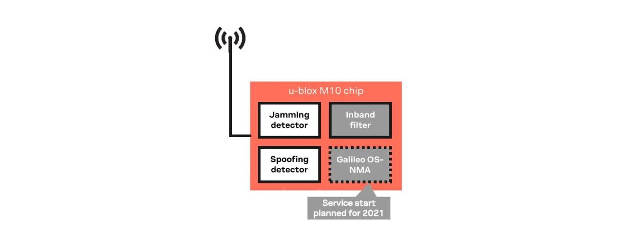
Galileo, the European Union's Global Navigation Satellite System, provides a way for GNSS receivers to verify that they are receiving accurate satellite signals from the Galileo constellation. This strategy makes it harder for hackers to perform their "job." Initially, only the European GNSS Platform for Smart Wearable devices constellation will provide civilian users free authenticated navigation messages.
Galileo is Europe's contribution to the Global Navigation Satellite System (GNSS), which aims to improve global positioning, navigation, and weather forecasting. Galileo is unique among GNSS systems in that it is governed by a civil agency, the European Space Agency (ESA). Its architecture is based on feedback from a wide range of users.
At an altitude of almost 23,000 kilometres, 30 satellites (24 active and 6 spares) make up the Galileo satellite segment. Each satellite will take around 14 hours to complete one full circle of the Earth, and they will be dispersed evenly across three different orbital planes.
In continuous tracking mode, the U-blox M10 consumes just 12 mW, making it an excellent choice for devices that run on batteries. After activation, the M10's enhanced sensitivity to radio frequencies allows the platform to find its first stable position with a small antenna.
According to the results of two separate experiments in Australia and Germany, Super-S and the upgraded "Super-E" mode allow even more power reduction with lower update rates, maximizing the measurement in cases where the signal is feeble (figure 3).
Super-S technology was developed to address the issues of poor antenna placement and weak GNSS signals. The quality of GNSS signals received by the positioning receiver can be degraded by several other circumstances, including inclement weather, obstructions to the sky view, and urban canyons; Super-S technology solves all of these issues. u-blox Super-S technology combines two sizes to accommodate these types of situations.
Receivers for global navigation satellite systems (GNSS) can either be in the "acquisition" or "tracking" phase of operation. In the first stage, sensitivity increases, and the acquisition time is shortened by acquiring a position with a higher probability and using less energy. The next step is to hold this position at all costs.
Figure 3's left side features a 1 and a 2, as shown here. As shown in number one, the buildings in number two are far taller than those in number one. And if you glance to the right, you will notice that all these lines of various hues eventually converge on the green, which indicates the most direct and accurate course.
Then there is the blue M10 and the yellow M8. For the top spot, there is essentially no variation. They give a reasonably accurate account of events. However, if you compare it to #2, you will notice a distinction. There is a yellow line there.
The reliability of the data obtained by receivers is crucial for mission-critical applications. Maximum position error and system dependability are both described and quantified by the protection level. At this granularity, all typical types of inaccuracy in GNSS Platform for Smart Wearable devices systems start to have an effect.
There is a continuous and rapid development of new systems and technologies in the GNSS (Global Navigation Satellite System) industry.
As a result, several countries, including the Russian GLONASS, the Chinese Beidou, and the European Galileo, joined the race to develop more accurate alternative systems, resulting in the GNSS Platform for Smart Wearable devices (Global Navigation Satellite Systems). Galileo data aids in the tracking down of distress signals and the rescue of those in peril in a wide variety of settings.